What Is a Real-Time Location System (RTLS)?
An RTLS is an integrated system of hardware and software that continuously tracks the physical location of tagged objects — assets, equipment, vehicles, or people within a defined space. Unlike barcode scanning or periodic RFID audits that capture location at a specific moment, RTLS provides continuous, live location data that updates as tagged items move.
The core components of an RTLS are:
- Tags attached to each tracked asset.
- Fixed infrastructure (readers, anchors, or access points) distributed throughout the tracked environment that detect tag signals.
- Software that calculates and displays location in real time on a map or floor plan.
When an asset moves, the system detects the movement, calculates the new position, and updates the display — typically within seconds.
TL;DR
A Real-Time Location System (RTLS) is a technology framework that automatically identifies and tracks the location of assets (or people) in real time within a defined environment. RTLS combines tags attached to assets with infrastructure (readers, sensors, or anchors) that detect and report each tag’s position to a central software platform — enabling live location visibility without manual scanning.
RTLS Technologies: A Comparison
Technology |
Accuracy |
Range |
Best Fit |
Key Trade-Off |
| UWB (Ultra-Wideband) | 10–30 cm (sub-metre) | Short to medium | Precision indoor tracking — hospitals, data centres | Higher infrastructure cost; denser anchor network needed |
| BLE (Bluetooth Low Energy) | 1–3 metre zone | Short to medium indoor | Office equipment, wearables, shared tools | Lower precision; sufficient for zone-level tracking |
| Passive RFID | Zone or read-point level | Up to 10 metres (UHF) | Asset audits, gate/chokepoint detection | Not continuous — reads at fixed reader points only |
| Active RFID | Zone level | Up to 100+ metres | Large indoor environments, warehouses | Tag battery life; medium precision |
| GPS | 1–5 metre outdoor | Wide area / unlimited | Vehicles, outdoor assets, field equipment | Does not work reliably indoors |
| Wi-Fi RTLS | 3–15 metre zone | Leverages existing Wi-Fi | Lower-cost indoor deployment over existing infrastructure | Lower accuracy; depends on Wi-Fi density |
Key Differences Between RTLS, RFID, and GPS
These technologies are often confused because they all relate to tracking. The key difference lies in how continuously they track assets and the environments they operate in.
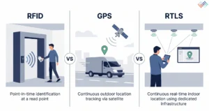
- RFID (radio frequency identification) is a technology that enables contactless reading of tags. It can be used as a component within an RTLS, but RFID alone (especially passive RFID) typically provides point-in-time location data at fixed read points, not continuous real-time tracking.
- GPS provides continuous outdoor location tracking using satellite signals. It is effective for vehicles and field assets but does not work reliably inside buildings.
- RTLS is the complete system combining a tagging technology (BLE, UWB, active RFID, Wi-Fi) with infrastructure and software to deliver continuous, real-time indoor location. RTLS can use RFID or BLE as its underlying radio technology.
Enterprise Use Cases for RTLS
Industry |
RTLS Use Case |
Asset Types Tracked |
| Healthcare | Medical equipment location, patient flow | Infusion pumps, wheelchairs, portable monitors, beds |
| Manufacturing | WIP tracking, tool location, production flow | Jigs, tools, pallets, work-in-progress units |
| Warehousing / Logistics | Forklift and pallet tracking, dock management | Forklifts, pallets, shipping containers |
| Data Centre | Server and rack location, asset compliance | Servers, rack components, cable infrastructure |
| Construction | Tool and equipment visibility on large sites | Power tools, heavy equipment, safety equipment |
| Banking / BFSI | IT hardware and branch equipment visibility | Laptops, scanners, ATM components, branch assets |
Benefits of RTLS for Asset Management
- Continuous location visibility– Eliminates the time spent searching for misplaced assets, particularly in large facilities where assets move frequently between departments or zones.
- Automated audit trails– Every location change is timestamped and logged, providing a complete movement history for each asset without requiring manual verification.
- Geofencing integration– RTLS can trigger alerts when assets leave defined zones, supporting theft prevention and unauthorized movement controls.
- Utilization intelligence– Continuous location data reveals where assets spend their time, enabling utilization analysis that periodic audits cannot provide.
- Register accuracy– Location data from RTLS feeds directly into the asset register, keeping location fields current without manual updates.
Best Practices for RTLS Deployment
- Define location accuracy requirements before selecting a technology — zone-level accuracy (is the asset in Room A or Room B?) requires a different investment than sub-metre precision tracking.
- Conduct a site survey before deployment to assess infrastructure requirements, wall materials, interference sources, and coverage gaps all affect RTLS performance.
- Integrate RTLS location data directly into your asset management platform so that location updates flow into asset records automatically, not as a separate dataset.
- Start with high-value or high-movement asset categories where location uncertainty costs the most — this builds the business case for broader RTLS expansion.
How AssetCues Integrates with RTLS
AssetCues connects with IoT-based location systems and RTLS infrastructure to synchronize real-time location data with the asset register. Asset location, movement history, and zone alerts are captured in the platform — giving operations and finance teams live visibility into where assets are and how they are being used.
